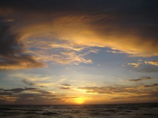
California Sunset

California Sunset
One of our favorite camping spots at Rincon Parkway, old Route 1, north of Ventura, CA

Tour Itinerary

Tour Itinerary
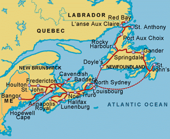
49-Day Maritime Provinces Tour with Adventure Caravans

Tuesday, June 17, 2008

Treasured Family Moments

June 17, 2008

We’ve spent the past 4 days visiting Steve’s family in Connecticut. Cousin Dawn, husband Charlie, their daughter Tabitha, her husband Jim and 2-and-a-half year old Allison entertained us over the weekend. We parked on Dawn and Charlie’s driveway in Winsted and celebrated Father’s Day weekend with the family. It was great fun touring the back roads of this rural part of Connecticut, revisiting the town where Steve’s mom and Aunt Francie grew up, and renewing acquaintances. Steve and Charlie were able to locate his YMCA summer camp and a waterfall where he camped several times as a youth. Campbell Falls Park straddles the Connecticut-Massachusetts border. There are inscribed granite markers in the woods along the trail identifying the position of the state line. Steve remembers being thrilled to stand with one foot in each of the two states while poised over one of the markers. We had an excellent Father’s Day brunch buffet at a supper club on a lake with Dawn, Charlie and many other members of their extended family.

Then we went to the southern shore of Connecticut to visit cousin-in-law Harry and Mary in Stratford. They had just returned from Florida and are in the process of moving there to enjoy the golfing and retirement life in The Villages, near Ocala. Harry took us to visit Steve’s Aunt Blanche at her assisted living center in Wallingford, CT. We also toured New Haven and walked around the historic parts of the campus at Yale University. We couldn’t bring the motorhome up the narrow driveway to Harry’s house. So, we stashed it at the park-and-ride at an entrance to the Merritt Parkway for two days, returning to tend the dogs and to sleep there.

We’re now off along the Connecticut shore on I-95 and will shortly turn north toward Massachusetts. We’ll spend two days visiting Old Sturbridge Village then go on to the home of Steve’s college roommate in Pepperell, MA for a visit next weekend.

Friday, June 13, 2008

Diamond Mines in NY?!!!

June 13, Friday

We left Niagara Thursday morning and drove east on the New York State Thruway, a toll road with limited access. It is often 12-15 miles between exits and traffic flows smoothly. We arranged in advance for an EZ Pass, an electronic transponder that is good on many of the toll roads in the East and Midwest. NY gives a discount to motorhomes on the Thruway, charging EZ pass holders the passenger car rate. We drove toward Albany but stopped a little west in the Village of Herkimer. The Herkimer KOA is about 6 miles north of the highway but the diversion is well worth the trip. In addition to the campground, the location includes the Herkimer “Diamond” Mine and Museum. Herkimer diamonds are actually unusual quartz crystals that precipitate out of silica inside hollow rocks in the sandy shelf of the area. The best ones form double-pointed needles. One can dig in the matrix and keep any “diamonds” you find, or buy crystals and finished jewelry.

The campground is along a pretty creek. We were parked nose to the bank so we had a full-screen view of a gently rippling green ribbon of water.

Wednesday, June 11, 2008

Waterfalls are WET

June 11, Wednesday

The NY State Park at Four Mile Creek is beautiful! The sites are the largest we’ve ever had at ANY park, private or public. They also have electricity, and we’re grateful because we’re getting some warm weather, along with summer showers that send the humidity soaring. It’s on the shore of Lake Ontario and you can see Canada across the water.

We’ve been out exploring the sights. First stop was Fort Niagara, just 5 miles from camp. This fort was built by the French to secure the portage (path to carry canoes around the Falls) at the mouth of the Niagara River. It was captured by the British then was the site of several battles during the War of Independence and the War of 1812. The US military used it for training until the 1970’s. Then it became a historic landmark with costumed interpreters teaching the public about this era. We watched a “lobsterback” (a British officer) train some “new recruits” (children on a field trip) in parade drill. Then, an “irregular” (local volunteer) prepared and fired his musket loaded with black powder.

Next stop was the Power Authority hydroelectric plant Visitor Center. Water from the river is piped around the town of Niagara Falls through a huge conduit then released over a dam to drive the turbines. The diverted water reduces the volume at the Falls so less is diverted during the day (to keep visitors happy) and more is used at night. To even out the power generation, some water is pumped up at night and stored in a head pond above the dam for daytime release.

Then, we visited the NY State Park area around the American Falls. There’s a green belt along the river bank and a trolley that runs the full length of the park. So, we parked at the north end and rode around. The highlights included a ride on the boat, Maid of the Mist, to the base of both the American and Horseshoe (Canadian) Falls, and an elevator ride down to Cave of the Winds, where you can walk along the edge of Bridal Veil Falls. As you board the Maid of the Mist, you get a thin plastic raincoat to protect your clothes. Well, you STILL get pretty wet! The force of the water hitting the lower river is so strong that it throws up a tremendous mist. You get so close that you feel as well as hear the roar of the falling water just a few feet way. The boat captain fights a strong current to hold the boat close to the falls in turbulent water. After drying off in the midday sun and having lunch, we moved a bit upstream and descended several hundred feet in an elevator to the bottom of the cliff next to Bridal Veil Falls. There used to be a cave behind this waterfall that people could enter. However, it was destroyed when a section of cliff collapsed. Now, the park builds walkways along the rubble at the cliff bottom to allow people to go up to the side of the cataract. The walkways have to be rebuilt almost entirely each spring so never follow exactly the same path from year to year. Again, you can get quite wet from the spray but also get to see the pools and rivulets that form at the base. This area is also a large gull rookery at this time of year and the smell of the guano was pungent. There were many chicks among the rocks just off the path and other nests with females sitting on eggs still.

We didn’t cross to the Canadian side after all, although we almost drove across Rainbow Bridge by accident without our passports in hand. Luckily, Steve was able to safely back away from the toll plaza without having to cross.

Monday, June 9, 2008

New York, New York!

June 9, Monday

Leaving Pennsylvania, the I-90 turns into the New York State Thruway, a toll road, about 40 miles east of our last overnight stop. Occasionally we are treated to a view of Lake Erie off to the left. An EZ-Pass transponder, ordered well in advance, let us just cruise through tollbooths. The Thruway has few exits, set tens of miles apart, and a good surface, so we made excellent time. In the middle of this ~60 mile segment, there was a service area with food service and a gas station right on the highway (kind of a super rest area with commercial services). We remember similar embedded service areas from our childhood trips around New England, but there’s no equivalent in the West.

After passing through central Buffalo, we turned north along the Niagara Falls. I exited the freeway too soon onto a road that ran along the shore then turned into the heart of the City of Niagara Falls. After negotiating some tricky traffic, we followed Robert Moses Parkway north to Fort Niagara then east to Four Mile Creek State Park campground. The campground has the most spacious sites we’ve ever seen and a nice view of Lake Ontario. This evening, some thunderheads formed over the lake and we even had a light shower. Does this mean that the heat wave is breaking? We sure hope so.

Tomorrow and Wednesday we’ll sightsee in the area, crossing into Canada also to see their side of the Falls. Steve has been reading the classic Sherlock Holmes stories by Sir Arthur Conan Doyle and was fascinated by passages describing Holmes’s “death” at Reichenbach (sp?) Falls. His colleague, Ted, was stationed at Niagara Falls during the Korean War, and we’re looking forward to seeing some of the sights he’s described.

Sunday, June 8, 2008

Turning North

June 8, Sunday

This was a travel day across Ohio and into Pennsylvania. Again, traffic around Columbus and Cleveland was light thanks to the weekend. We were amazed at how compact the cities are and how rural are their outskirts. There were far too many dead deer along the roads and we vowed to avoid travel at night. (We don’t like to drive the RV at night anyway but we renewed our decision to pull off the road well before dusk.) The damage to the deer is distressing to see and we can only imagine what the impact would do to the motor home’s fiberglass front cap.

We stopped at a small private campground just west of Erie, PA. We used the laundry facilities to wash all the dusty sweaty clothes from our cave tours then went into Erie for dinner at a local grill. It was strange to follow rural roads that curve, dip and cross at oblique angles. We were reminded that on the East Coast, roads follow streams and Indian trails rather than a rectangular grid. A Walmart stop completed the evening; we’re still discovering forgotten items and restocking consumables. We’ll leave for Niagara Falls tomorrow morning.

Saturday, June 7, 2008

Caving and More Caving

June 7, Saturday

Our descent into the new entrance was peculiar, to say the least. A path through the woods leads to an open area and a large, locked metal door set into the side of a sinkhole. Through the door, we descended many steps into a large, dry passageway. In several places, water from above dripped on us and ran down the cave walls. After about two miles of passage and many ramps and steps, we reached the star attraction of this part of the cave. The Frozen Niagara formation is one of the few examples of flowstone in the cave. This is the only public area with stalactites and stalagmites. It was distressing to see how many were broken. Over a hundred years of tourism during private ownership certainly took its toll. (We were stuck by the contrast with Kartchner Caverns, in a state park near Benson, AZ, which we toured about 5 years ago. This is also a wet living cave but recently opened to the public and fiercely protected. Every formation is pristine.) Our concerns about having to ascend the entry steps were relieved – the exit was just a short ascent from the Frozen Niagara and out a different metal door set in a hillside.

The cave is 54 degrees and the air temperature was at least a very humid 90 degrees! What a contrast! We quickly were covered in sweat and found it hard to breathe. When we got back to the coach, we HAD to turn on the generator and air conditioning to cool down again. All the park staff complained about the unseasonable heat which has followed us across the country.

This morning we took our final cave tour, the Historical Tour using the historic entrance. We retraced a little of the same path as our first tour, as far as the saltpeter mill works, then turned off to a different part of the cave. We followed passages discovered and named by Stephen Bishop, a black slave tour guide of the 1830’s – 50’s. He reportedly crossed Bottomless Pit after laying down a log and shimmying along it over a huge chasm. We walked across on a metal bridge. We entered at the bottom of Mammoth Dome then climbed 249 steps to exit near the top of the chamber, a feat impossible in historic tours. There were many examples of historic graffiti, names and inscriptions made by candle smoke on the cave ceiling. One passage, River Walk, occasionally floods during wet springs and had damp soil underfoot; the guide said that last month it held 5 feet of water and has been completely flooded with up to 12 feet at times. One passage is named Tall Man’s Misery – we had several hundred feet of low ceiling that we had to stoop-walk under. Another passage is Fat Man’s Misery, a narrow twisty passage formed by fast-moving water.

After finishing the tour, we broke camp and drove across Kentucky into Ohio. We were lucky to be traveling on a weekend. There were many road work projects suspended for the weekend and traffic through Louisville and Cincinnati was very light. We stopped south of Columbus in a very rural area at a nice campground. Tomorrow we’ll aim for Erie, PA then on into New York, specifically Niagara Falls on Monday.

Friday, June 6, 2008

Underground Tourists

June 6, Friday

We crossed Tennessee in a day and entered Kentucky yesterday afternoon. The terrain is rolling hills then dips. The National Park staff explained that the dips are sinkholes where a cave or cavern has formed in the limestone rock. Mammoth Cave is the longest cave system in North America with >360 miles of mapped passages on 7 levels with many more still uncharted.

Last night we went on our first tour, by lantern light, to the Star Chamber. This room got its name in the earliest days of tourism at Mammoth Cave, about 1815, when guides would throw rocks to chip off black gypsum from the ceiling, exposing sparking white “stars”. We also saw the remains of a nitrate mine used for domestic gunpowder manufacture during the War of 1812. Calcium nitrate was mined from the cave soil, leached, piped aboveground and boiled down to precipitate saltpeter, potassium nitrate, then shipped to E.I. DuPont in Delaware for making gunpowder. The nearly 200-year-old wood is perfectly preserved, as are other artifacts left by early Woodland Indians as long as 4000 years ago.

This morning, a wild turkey and a white-tail doe strolled through camp without any notice of or concern for the dogs and us. They must know that they’re protected in the National Park. This afternoon, we’ll tour another deeper and wetter park of the cave, using the “New Entrance” deliberately created when an early cave entrepreneur dropped 26 sticks of dynamite down a sink hole.